The visual phenomenon of blood-red skies in Western Australia during the approach of Cyclone Narelle is not a mere aesthetic anomaly; it is the measurable result of Mie scattering and high-velocity lithometeor transport. When a severe tropical cyclone interacts with the arid topography of the Pilbara and Gascoyne regions, it creates a massive pressure gradient that transforms the landscape into a source of particulate matter. This interaction dictates the visual spectrum of the horizon and serves as a precursor to the hydrological impact of the storm system.
The Mechanics of Chromatic Shift
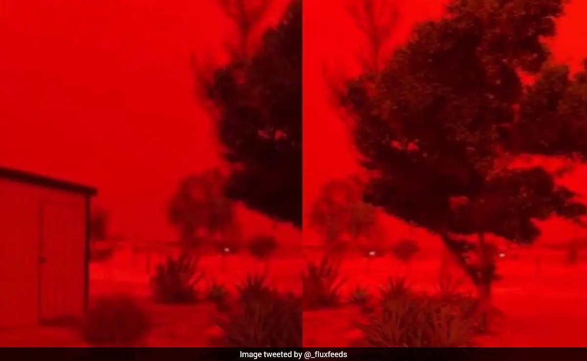
The shift in the sky’s color from blue to deep red is governed by the interaction between solar radiation and suspended solids. Under standard atmospheric conditions, Rayleigh scattering dominates. This occurs when sunlight interacts with molecules smaller than the wavelength of light (primarily nitrogen and oxygen), scattering shorter wavelengths—blues and violets—more effectively.
The approach of Cyclone Narelle introduces a fundamental shift in the medium through which light travels. As the storm's outer circulation intensifies, it pulls dry, inland air toward the coast. This air carries a high concentration of iron oxide-rich dust, typical of the Western Australian outback. These dust particles are significantly larger than gas molecules, often ranging from 0.1 to 10 micrometers.
The Mie Scattering Variable
When particle size is comparable to or larger than the wavelength of visible light, Mie scattering becomes the primary optical driver. Unlike Rayleigh scattering, Mie scattering is not strongly wavelength-dependent, but in the specific context of a dust storm (a "haboob" effect), it preferentially allows longer wavelengths to penetrate the haze.
- Absorption Profile: The mineralogical composition of the dust—specifically hematite and goethite—absorbs blue and green light.
- Forward Scattering: The remaining red and orange wavelengths are scattered forward toward the observer.
- Optical Depth: As the concentration of particulate matter increases, the optical depth rises, filtering out all but the most intense red frequencies of the solar spectrum.
This creates a feedback loop where the increasing wind speeds of the pre-cyclone environment directly correlate with the saturation of the red hue in the atmosphere.
The Cyclonic Engine: Pressure Gradients and Dust Entrainment
The "Red Sky" event is a diagnostic indicator of the storm's internal dynamics. Cyclone Narelle, as a Category 4 system at its peak, functioned as a heat engine requiring a specific set of atmospheric inputs. The dust storm preceding it was a byproduct of the Inflow Jet.
In the quadrant ahead of the cyclone's path, a tight pressure gradient exists between the low-pressure center of the storm and the high-pressure system sitting over the Australian continent. This gradient creates a "fetch" of high-speed winds that sweep across the desert floor.
The Saltation Threshold
Dust entrainment occurs through a process called saltation. Once wind speeds hit a critical threshold—typically 15 to 25 knots depending on soil moisture—sand grains begin to hop across the surface. When these grains land, they impact smaller dust particles, ejecting them into the air.
- Vertical Transport: The convective instability ahead of Narelle’s rainbands provides the lift necessary to carry this dust into the mid-troposphere.
- Horizontal Advection: The cyclonic rotation then pushes this wall of dust toward coastal population centers like Onslow and Karratha.
The red sky is effectively a visualization of the storm’s "breathing" mechanism, where it draws in continental air before the arrival of the core eyewall and its associated moisture.
Infrastructure Vulnerability and the Cost Function of Particulate Load
Analyzing the impact of the Narelle dust event requires a shift from visual observation to operational risk management. The intersection of a major dust event and a tropical cyclone creates a dual-threat environment that exceeds the design parameters of standard coastal infrastructure.
Kinetic Abrasion vs. Hydrostatic Pressure
While the cyclone itself brings the risk of hydrostatic pressure from storm surges and wind loading, the preceding dust storm introduces kinetic abrasion. High-velocity iron oxide particles act as an industrial sandblaster.
- Solar Array Degradation: Particulate buildup on photovoltaic cells during the red sky phase leads to immediate efficiency drops of 30% or more. If followed by light rain rather than a heavy downpour, this dust turns into a conductive "mud" that can cause electrical tracking and short circuits.
- Turbine Ingestion: For heavy machinery and power generation units in the mining sector, the ingestion of fine silicate dust leads to accelerated wear on internal components and filters, often requiring emergency shutdowns before the wind speeds themselves necessitate such action.
The Logistics Bottleneck
The visibility reduction during the Mie scattering phase (often down to less than 100 meters) creates a critical lag in evacuation and "tie-down" procedures. Port operations in the Pilbara, which handle a significant percentage of global iron ore trade, must synchronize their closure not with the arrival of the rain, but with the arrival of the dust wall. The transition from a blue sky to a red sky marks the closure of the operational window for safe maritime pilotage.
Distinguishing Atmospheric Signals from Meteorological Noise
It is vital to distinguish between a "Red Sky at Night" (a general indicator of high pressure and fair weather to the west) and the "Cyclonic Glow" observed during Narelle.
The standard "Red Sky at Night" is caused by sunlight passing through a high-pressure cell where the air is stable and trapped aerosols scatter the light. In contrast, the Narelle event is characterized by Turbulent Suspension. The red sky here is not a sign of stability; it is a sign of extreme kinetic energy moving through an arid environment.
The presence of the red sky specifically indicates:
- Low Soil Moisture: If the inland regions had recently received rain, the saltation threshold would be higher, and the dust event would be suppressed.
- Directional Shear: The dust indicates that the low-level inflow is coming from a continental source rather than a maritime one, suggesting the storm's circulation is broad enough to tap into land-based air masses.
Quantification of the Narelle Event
To understand the scale of Narelle’s impact, we must look at the energy conversion involved. A Category 4 cyclone releases latent heat at a rate equivalent to nearly 200 times the world's total electrical generating capacity. A fraction of this energy is diverted into the friction between the atmosphere and the lithosphere.
During the peak of the Narelle dust wall, the mass of suspended mineral matter over the coastal fringe was estimated in the hundreds of thousands of tons. This mass represents a significant redistribution of topsoil, which alters the local nutrient cycle but also poses a severe respiratory risk. The "Red Sky" is a marker of PM10 (particulate matter under 10 micrometers) concentrations that can spike to over 1000 micrograms per cubic meter—far exceeding safe health thresholds.
The Moisture Barrier Effect
One overlooked aspect of the pre-cyclone dust storm is its effect on the storm’s eventual precipitation. Dust particles act as Cloud Condensation Nuclei (CCN). An overabundance of CCN can actually "choke" cloud development initially by spreading available moisture across too many small droplets, preventing them from growing large enough to fall as rain. This explains why the "red sky" period is often eerily dry and hot before the sudden, violent onset of the primary rainbands.
Strategic Response Protocols for Arid Zone Cyclones
The occurrence of the Narelle dust event dictates a specific hierarchy of response for industrial and civic leaders in the region.
The first priority is the Sealing of Critical Systems. Standard cyclone prep focuses on "boarding up" against wind. In a red-sky scenario, the priority must shift to "sealing off" against micron-scale dust. HVAC systems must be switched to internal circulation or shut down entirely to prevent the infiltration of abrasive dust into sensitive server rooms and medical facilities.
The second priority involves Water Management. The transition from a dust storm to a cyclone involves a rapid shift from extreme dry to extreme wet. This creates "flash mud" conditions. Drainage systems that are bone-dry will suddenly be hit with a slurry of dust and high-volume rain. This slurry has a higher density than pure water, increasing the force it exerts on culverts and bridges.
Finally, the Logistical Buffer must be recalculated. If the red sky reduces visibility 12 hours before the wind speeds reach gale force, the "safe movement" window for heavy equipment is 12 hours shorter than the standard meteorological forecast suggests.
The "Red Sky" of Narelle is a warning system written in the physics of light. It marks the precise moment when a maritime weather system begins to consume a continental environment. Operational success in these regions depends on recognizing that the color of the sky is not a spectacle, but a data point indicating the arrival of a multi-phase geological and meteorological event.
The strategic play for future systems of Narelle’s profile is the deployment of real-time aerosol LIDAR (Light Detection and Ranging) to map the density of the dust wall. This allows for a more granular shutdown of port and mining assets, moving away from broad "cyclone alerts" to specific "particulate-impact" windows, thereby minimizing unnecessary downtime while protecting high-value mechanical assets from the abrasive pre-storm surge.